About OsmAnd Maps Travel & Navigate
OsmAnd is an offline world map application based on OpenStreetMap (OSM), which allows you to navigate taking into account the preferred roads and vehicle dimensions. Plan routes based on inclines and record GPX tracks...
OsmAnd is an offline world map application based on OpenStreetMap (OSM), which allows you to navigate taking into account the preferred roads and vehicle dimensions. Plan routes based on inclines and record GPX tracks without an internet connection.
OsmAnd is an open source app. We do not collect user data and you decide what data the app will have access to.
Main features:
Map view
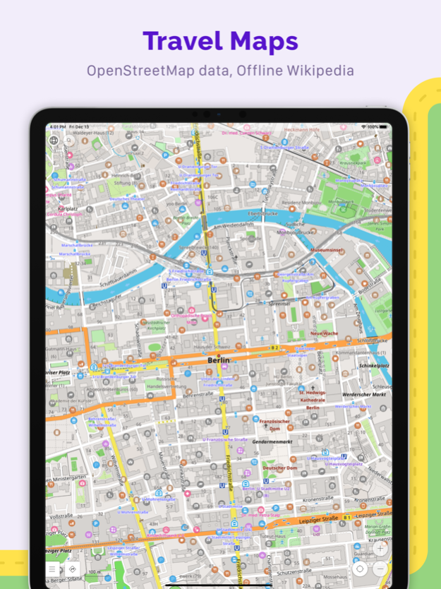
• Choice of places to be displayed on the map: attractions, food, health and more;
• Search for places by address, name, coordinates, or category;
• Map styles for the convenience of different activities: touring view, nautical map, winter and ski, topographic, desert, off-road, and others;
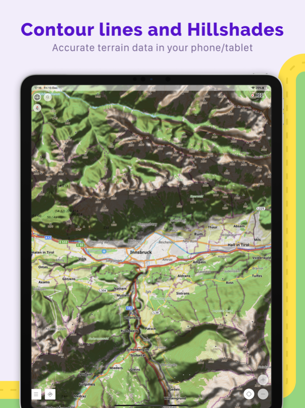
• Shading relief and plug-in contour lines;
• Ability to overlay different sources of maps on top of each other;
GPS Navigation
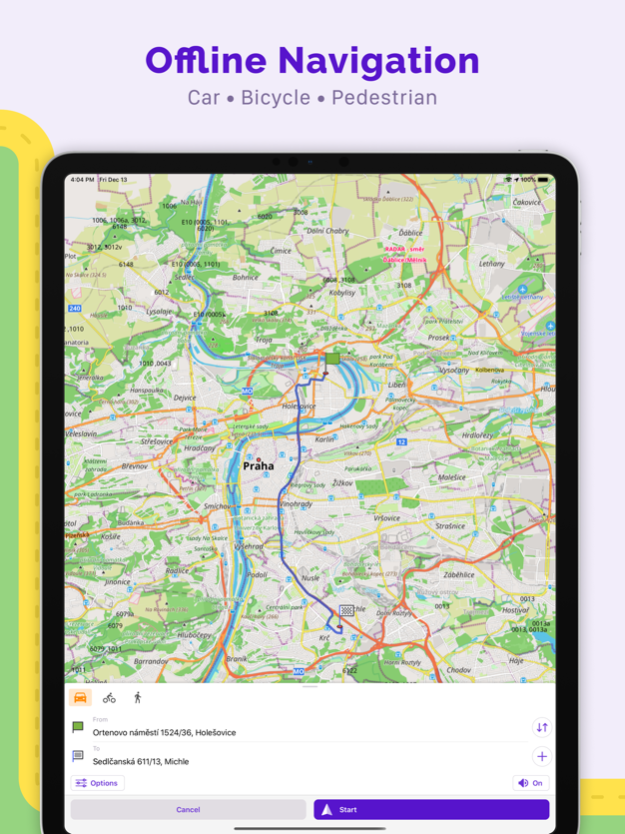
• Plotting a route to a place without an Internet connection;
• Customizable navigation profiles for different vehicles: cars, motorcycles, bicycles, 4x4, pedestrians, boats, public transport, and more;
• Change the constructed route, taking into account the exclusion of certain roads or road surfaces;
• Customizable information widgets about the route: distance, speed, remaining travel time, distance to turn, and more;
Route Planning and Recording
• Plotting a route point by point using one or multiple navigation profiles;
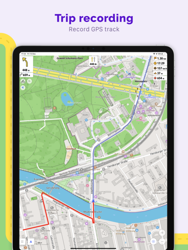
• Route recording using GPX tracks;
• Manage GPX tracks: displaying your own or imported GPX tracks on the map, navigating through them;
• Visual data about the route - descents/ascents, distances;
• Ability to share GPX track in OpenStreetMap;
Creation of points with different functionality
• Favourites;
• Markers;
OpenStreetMap
• Making edits to OSM;
• Updating maps with a frequency of up to one hour;
Additional features
• Compass and radius ruler;
• Mapillary interface;
• Night theme;
• Large community of users around the world, documentation, and support;
Paid features:
OsmAnd Maps+ (in-app or subscription):
• Unlimited map downloads;
• Topo data (Contour lines and Terrain);
• Nautical depths;
• Offline Wikipedia;
• Apple CarPlay support;
OsmAnd Pro (subscription):
• All Maps+ features;
• Weather forecast on the map online/offline;
• OsmAnd Cloud (backup and restore);
• Customize Route line;
• Hourly map updates.
Apr 19, 2024
Version 4.7
• Enhanced top and bottom widget panels to accommodate all widgets
• Improved management for tracks visible on the map
• Updated "Analyze on Map" with the ability to display metrics from sensors
• Enhanced tags support for GPX has been added: link, author, copyright, and keywords.
• Improved widgets configuration by allowing users to move pages and rows
• Improved track management in the "My Places" with subfolders and context menus for tracks and folders
• Roundabout with exit number now shown on CarPlay when navigating
• Control the 3D relief with a new "Vertical exaggeration" option for a more dramatic landscape
• Visualize track elevation directly on the map in a dynamic 3D view
• New widgets: "Glide Ratio" and "Sun Position"
• Customize "Distance during navigation": choose between precise or round up numbers
• App language will be used for names on the world overview map instead of local languages
• OsmAnd Cloud: Added ability to manage your data, including restoring deleted files and deleting your account
• Added additional tags support for tourist routes
• Fixed the "Coordinates" widget where, in some cases, the last digits were missed
• Fixed "3D Mode" button behavior: tapping on the button doesn't save the tilt angle
• Fixed status bar color for older iOS versions
• Fixed rotate and pinch to zoom map gestures for the app running on macOS
Previous Versions
Here you can find the changelog of OsmAnd Maps Travel & Navigate since it was posted on our website on 2016-09-26 02:22:47.
The latest version is 4.7 and it was updated on 2024-04-19 17:18:19. See below the changes in each version.
OsmAnd Maps Travel & Navigate version 4.7
Updated At: 2024-04-19
Changes: Apr 19, 2024
Version 4.7
• Enhanced top and bottom widget panels to accommodate all widgets
• Improved management for tracks visible on the map
• Updated "Analyze on Map" with the ability to display metrics from sensors
• Enhanced tags support for GPX has been added: link, author, copyright, and keywords.
• Improved widgets configuration by allowing users to move pages and rows
• Improved track management in the "My Places" with subfolders and context menus for tracks and folders
• Roundabout with exit number now shown on CarPlay when navigating
• Control the 3D relief with a new "Vertical exaggeration" option for a more dramatic landscape
• Visualize track elevation directly on the map in a dynamic 3D view
• New widgets: "Glide Ratio" and "Sun Position"
• Customize "Distance during navigation": choose between precise or round up numbers
• App language will be used for names on the world overview map instead of local languages
• OsmAnd Cloud: Added ability to manage your data, including restoring deleted files and deleting your account
• Added additional tags support for tourist routes
• Fixed the "Coordinates" widget where, in some cases, the last digits were missed
• Fixed "3D Mode" button behavior: tapping on the button doesn't save the tilt angle
• Fixed status bar color for older iOS versions
• Fixed rotate and pinch to zoom map gestures for the app running on macOS
OsmAnd Maps Travel & Navigate version 4.6.3
Updated At: 2024-01-21
Changes: Jan 21, 2024
Version 4.6.3
• Record and track your metrics with external sensors including Bicycle speed, Bicycle Cadence, Bicycle Distance, Heart rate and temperature
• Now you can view map directly on your CarPlay dashboard
• Added Night theme for a comfortable viewing experience in low light conditions
• Discover travel guides by "Wikivoyage"
• Improved dialogs for adding notes and uploading notes and POIs to OpenStreetMap
• Easily restore your plugin settings to the installation defaults with a new 'Reset to Default' option
• Added a "Screen orientation" option to set your preferred orientation without automatic switching
• Added a separate button to switch 3D Mode directly on CarPlay screen
• Minimum and maximum elevation information has been added to navigation routes in addition to uphill and downhill
• Improved track coloring in Slope mode with new symmetric gradient
• Favorite folders now store default appearance that are applied automatically to each added point
• Fixed the "Radius ruler" center point mismatching with the map center
• Added "Read article" button for Wikipedia POIs context menu
• Fixed issue with importing GPX file to favorites
• Fixed issue with the calendar event for parking position
• Fixed crash with removing color from pallet
OsmAnd Maps Travel & Navigate version 4.6.2
Updated At: 2024-01-11
Changes: Jan 11, 2024
Version 4.6.2
• Record and track you metrics with external sensors including Bicycle speed, Bicycle Cadence, Bicycle Distance, Heart rate and temperature
• Now you can view map directly on your CarPlay dashboard
• Added Night theme for a comfortable viewing experience in low light conditions
• Discover travel guides by "Wikivoyage"
• Improved dialogs for adding notes and uploading notes and POIs to OpenStreetMap
• Easily restore your plugin settings to the installation defaults with a new 'Reset to Default' option
• Added a "Screen orientation" option to set your preferred orientation without automatic switching
• Added a separate button to switch 3D Mode directly on CarPlay screen
• Minimum and maximum elevation information has been added to navigation routes in addition to uphill and downhill
• Improved track coloring in Slope mode with new symmetric gradient
• Favorite folders now store default appearance that are applied automatically to each added point
• Fixed the "Radius ruler" center point mismatching with the map center
• Added "Read article" button for Wikipedia POIs context menu
• Fixed issue with importing GPX file to favorites
• Fixed issue with the calendar event for parking position
• Fixed crash with removing color from pallet
OsmAnd Maps Travel & Navigate version 4.6
Updated At: 2023-12-20
Changes: Dec 20, 2023
Version 4.6
• Record and track you metrics with external sensors including Bicycle speed, Bicycle Cadence, Bicycle Distance, Heart rate and temperature
• Now you can view map directly on your CarPlay dashboard
• Added Night theme for a comfortable viewing experience in low light conditions
• Discover travel guides by "Wikivoyage"
• Improved dialogs for adding notes and uploading notes and POIs to OpenStreetMap
• Easily restore your plugin settings to the installation defaults with a new 'Reset to Default' option
• Added a "Screen orientation" option to set your preferred orientation without automatic switching
• Added a separate button to switch 3D Mode directly on CarPlay screen
• Minimum and maximum elevation information has been added to navigation routes in addition to uphill and downhill
• Improved track coloring in Slope mode with new symmetric gradient
• Favorite folders now store default appearance that are applied automatically to each added point
• Fixed the "Radius ruler" center point mismatching with the map center
• Added "Read article" button for Wikipedia POIs context menu
• Fixed issue with importing GPX file to favorites
• Fixed issue with the calendar event for parking position
• Fixed crash with removing color from pallet
OsmAnd Maps Travel & Navigate version 4.5.2
Updated At: 2023-10-18
Changes: Oct 18, 2023
Version 4.5.2
• Completely redesigned widget experience: added ability to change widget position, added grouping by pages, one list of widgets for left and right panel
• Redesigned configure screen
• Free backup of favourites, settings and OSM edits to OsmAnd Cloud
• Added "CAI" scale for "Difficulty classification of the routes"
• Added 3D Relief
• Added OAuth authorization for OpenStreetMap Editing plugin
• Added separate button to switch between 2D or 3D Mode
• Changed direction of tilt gesture
• Fixed issue with favorites export, that could lead to data loss
OsmAnd Maps Travel & Navigate version 4.5
Updated At: 2023-10-08
Changes: Oct 8, 2023
Version 4.5
• Completely redesigned widget experience: added ability to change widget position, added grouping by pages, one list of widgets for left and right panel
• Redesigned configure screen
• Free backup of favourites, settings and OSM edits to OsmAnd Cloud
• Added "CAI" scale for "Difficulty classification of the routes"
• Added 3D Relief
• Added OAuth authorization for OpenStreetMap Editing plugin
• Added separate button to switch between 2D or 3D Mode
• Changed direction of tilt gesture
• Fixed issue with favorites export, that could lead to data loss
OsmAnd Maps Travel & Navigate version 4.4.5
Updated At: 2023-05-31
Changes: May 31, 2023
Version 4.4.5
• New "Train" profile
• External keyboard: added support for new keys
• New widgets for Trip recording
• Added search for Favorites, Tracks, and OSM Edits
• CarPlay: history includes points that were used in navigation
• Emoji can now be used as favorites or waypoint name
• Fixed transition between offline Wikipedia articles
• Fixed issues with the import of custom routing and rendering files
• Track appearance: added ability to set any custom color
• New widget "Elevation: map center"
• Added option to disable announcing for deviation from the route
• Wikipedia: added ability to view images, updated reader UI
• Favorites: added search
• CarPlay: added history, reorganized tracks and favorites list
• Hiking routes: added ability to select routes on the map for viewing additional information or navigation
• OpenStreetMap: added ability to upload tracks
• New widget: show exact time of or time left to the next Sunrise or Sunset
• New widget: display coordinates for map center
• Improved support of external keyboards, added support for basic actions
• Voice prompts: added support for new languages: Catalan, Ukrainian, Bulgarian, Indonesian, Slovenian
• Added legal warning about using speed camera alerts
• Improved privacy: added options to disable history logging
• Improved visibility of the map ruler
• OsmAnd Cloud bug fixes and UI improvements
• UI improvements for RTL languages
• Accessibility: added content labelling for map buttons
• Added "Dynamic type" support, text size in OsmAnd will change accordingly to text size in iOS.
• Map orientation: added manually rotated mode
• New Moped profile
• Minimum iOS version is increased to 15.0
OsmAnd Maps Travel & Navigate version 4.4.1
Updated At: 2023-04-21
Changes: Apr 21, 2023
Version 4.4.1
• Wikipedia: added ability to view images, updated reader UI
• Favorites: added search
• CarPlay: added history, reorganized tracks and favorites list
• Hiking routes: added ability to select routes on the map for viewing additional information or navigation
• OpenStreetMap: added ability to upload tracks
• New widget: show exact time of or time left to the next Sunrise or Sunset
• New widget: display coordinates for map center
• Improved support of external keyboards, added support for basic actions
• Voice prompts: added support for new languages: Catalan, Ukrainian, Bulgarian, Indonesian, Slovenian
• Added legal warning about using speed camera alerts
• Improved privacy: added options to disable history logging
• Improved visibility of the map ruler
• OsmAnd Cloud bug fixes and UI improvements
• UI improvements for RTL languages
• Accessibility: added content labelling for map buttons
• Added "Dynamic type" support, text size in OsmAnd will change accordingly to text size in iOS.
• Map orientation: added manually rotated mode
• New Moped profile
• Minimum iOS version is increased to 15.0
OsmAnd Maps Travel & Navigate version 4.4
Updated At: 2023-04-05
Changes: Apr 5, 2023
Version 4.4
• Wikipedia: added ability to view images, updated reader UI
• Favorites: added search
• CarPlay: added history, reorganized tracks and favorites list
• Hiking routes: added ability to select routes on the map for viewing additional information or navigation
• OpenStreetMap: added ability to upload tracks
• New widget: show exact time of or time left to the next Sunrise or Sunset
• New widget: display coordinates for map center
• Improved support of external keyboards, added support for basic actions
• Voice prompts: added support for new languages: Catalan, Ukrainian, Bulgarian, Indonesian, Slovenian
• Added legal warning about using speed camera alerts
• Improved privacy: added options to disable history logging
• Improved visibility of the map ruler
• OsmAnd Cloud bug fixes and UI improvements
• UI improvements for RTL languages
• Accessibility: added content labelling for map buttons
• Added "Dynamic type" support, text size in OsmAnd will change accordingly to text size in iOS.
• Map orientation: added manually rotated mode
• New Moped profile
• Minimum iOS version is increased to 15.0
OsmAnd Maps Travel & Navigate version 4.3.5
Updated At: 2023-02-21
Changes: Feb 21, 2023
Version 4.3.5
• Smooth animation for location changes during movement
• CarPlay: added lanes, 2.5D view, fixed sound issues while connected over Bluetooth
• Introducing new purchase plans: "OsmAnd Pro" subscriptions with access to all features and "Maps+" purchase with unlimited map downloads and paid plugins access
• Added Cloud backup and Offline Weather forecast for OsmAnd Pro users
• New convenient ”Purchase" screen with the list of all purchases
• Benefits for active OpenStreetMap.org contributors
• Tracks can now be colored by altitude, speed, or slope
• Offline maps are now accessible via the Files app
• Favorites: added local backups generation after each change, backups accessible from the Files app
• POI saved to favorites will store and show all POI data even without an offline map
• GPX added support for link, cmt, desc tags and for any custom extensions
• Added mode for the Compass button
• Fixed an issue with UTM Coordinates format
• Fixed an issue with intermediate points in navigation
• Fixed an issue with the Purchases screen